เมื่อปี พ.ศ. 2505 ขณะนั้นยังเป็นนิสิตคณะรัฐศาสตร์ จุฬาลงกรณ์มหาวิทยาลัย ได้ดูจอมพลสฤษดิ์ ธนะรัชต์ ออกปราศรัยทางโทรทัศน์เรื่อง คำพิพากษาของศาลโลก จอมพลสฤษดิ์ ธนะรัชต์ พูดไปควักผ้าเช็ดหน้าออกมาเช็ดน้ำตาว่าเราจำเป็นต้องปฏิบัติตามคำพิพากษาของ ศาลโลกโดยการถอนกำลังออกจากพระวิหาร และต้องคืนโบราณวัตถุกลับไปให้กัมพูชา พร้อมกันนั้นก็ประกาศตัดสัมพันธ์ทางการทูตกับกัมพูชาและมอบหมายให้สหภาพพม่า เป็นผู้ดูแลทรัพย์สินของทางราชการไทยในพนมเปญและที่เมืองอื่น ๆ ทางรถไฟที่ทอดยาวจากหัวลำโพงไปถึงกรุงพนมเปญก็เป็นอันต้องหยุด ประเทศไทยประกาศปิดชายแดน ตั้งแต่นั้นมาทั้ง 2 ประเทศก็หมดความเป็นมิตรต่อกัน แต่ประชาชนของทั้ง 2 ประเทศตามชายแดน ซึ่งเป็นญาติพี่น้องกันต่างก็ยังไปมาหาสู่ติดต่อค้าขายกันตามปกติ จนนายพลลอนนอลรัฐประหารขับไล่ สมเด็จพระเจ้าสีหนุออกไปร่วมกับฝ่ายเขมรแดง เราจึงรื้อฟื้นความสัมพันธ์ทางการทูตกับประเทศกัมพูชาขึ้นมาใหม่ แล้วข่าวคราวเรื่องเขาพระวิหารก็เงียบหายไป
เมื่อปี 2506 พวกเรานิสิตรัฐศาสตร์ วิชาการปกครอง ต้องเรียนวิชากฎหมายแพ่งและพาณิชย์ บรรพ 5 และบรรพ 6 ว่าด้วยครอบครัวและมรดกกับท่านศาสตราจารย์ ม.ร.ว.เสนีย์ ปราโมช ซึ่งท่านเป็นคนไทยคนหนึ่งที่ร่วมอยู่ในคณะทนายของฝ่ายไทย หัวหน้าคณะทนายความของไทยเป็นฝรั่งเข้าใจว่าเป็นอเมริกัน ส่วนหัวหน้าทนายความของฝ่ายกัมพูชาเป็นชาวฝรั่งเศส
พวกเราก็กราบเรียนถามท่านอาจารย์ ม.ร.ว.เสนีย์ ปราโมช ว่า ประเด็นที่ต่อสู้กันนั้นว่าอย่างไร ท่านก็บอกให้พวกเรากลับไปอ่านคำพิพากษาของศาลโลกเสียก่อนแล้วท่านจะอธิบาย ให้ฟัง
เมื่ออ่านจบแล้วเราก็เข้าใจขึ้นเป็นอันมาก เพราะคำพิพากษาเขียนเหตุผลไว้อย่างละเอียด ทั้งคำฟ้องร้องของกัมพูชาและคำแก้คดีของฝ่ายไทย รวมทั้งเอกสารสนธิสัญญาแผนที่แนบท้ายสัญญา ลายพระหัตถ์ของสมเด็จกรมพระยาดำรงราชานุภาพ ที่ทรงมีไปถึงข้าหลวงฝรั่งเศสประจำกัมพูชา เรื่องขออนุญาตเสด็จไปเยี่ยมชมเขาพระวิหาร ภาพถ่ายสมเด็จกับ ม.จ.พูนพิศมัย พระธิดาเสด็จเขาพระวิหาร
ประเด็นที่ต่อสู้กันก็คือ แผนที่แนบท้ายสนธิสัญญาฉบับปี 1904 ที่ให้เอาสันปันน้ำเป็นเขตแดน แต่แผนที่แนบท้ายใช้มาตราส่วน 1 : 200,000 ขีดมาตามสันปันน้ำ แล้วมาวกเอาปราสาทเขาวิหารไปเป็นของกัมพูชา แล้วจึงวกกลับมาบนสันปันน้ำอีกทีหนึ่ง
เรารู้ว่าแผนที่นั้นผิดไม่ตรงกับตัวหนังสือในสนธิสัญญาปักปันเขตแดน ค.ศ. 1904 อีกทั้งไทยไม่เคยยอมรับแผนที่ที่ฝรั่งเศส ทำฝ่ายเดียวแล้วส่งมาให้ไทย ไทยรับรองให้ความเห็นชอบเพราะฝ่ายไทยไม่ได้ส่งตัวแทนไปร่วมคณะปักปันเขตแดน ตามที่ระบุไว้ในสนธิสัญญา
แต่ในที่สุดศาลโลกตัดสินว่าปราสาทพระวิหารเป็นของกัมพูชา เพราะแผนที่ แนบท้าย ค.ศ. 1904 เป็นส่วนหนึ่งของ สนธิสัญญาทั้งในแง่เอกสารและข้อเท็จจริงที่ทางไทยไม่ได้ทักท้วงภายใน 10 ปี อีกทั้งหัวหน้าคณะปักปันเขตแดนของฝ่ายไทยจะเสด็จเยี่ยมปราสาทพระวิหารก็ทรง มีลายพระหัตถ์ขออนุญาตข้าหลวงฝรั่งเศส ข้าหลวงฝรั่งเศสก็ออกมารับเสด็จพร้อมกับชักธงชาติฝรั่งเศสขึ้นสู่ยอดเสา มีการถ่ายรูปร่วมกัน
อาจารย์ ม.ร.ว.เสนีย์ ปราโมช ท่านเล่าให้พวกเราลูกศิษย์ฟังว่า ท่านรู้แต่แรกแล้วว่าเราคงจะแพ้คดี แต่โดยหน้าที่ที่เป็นคนไทยและจรรยาบรรณของทนายความก็ต้องทำหน้าที่ปกป้องผล ประโยชน์ของประเทศชาติอย่างถึงที่สุด
ท่านเล่าว่าทางที่ถูกเราไม่ควรตกลงให้กัมพูชานำคดีขึ้นศาลโลก เพราะคดีที่จะขึ้นสู่ศาลโลกได้ทั้งสองฝ่ายต้องยินยอมให้ศาลโลกพิจารณา
แต่จอมพลสฤษดิ์ท่านต้องการรักษาเกียรติภูมิของชาติว่าเราเป็นชาติอารยะ เป็นสมาชิกที่ดีขององค์การสหประชาชาติ และทนายฝรั่งเชื่อว่าฝ่ายเราจะเป็นฝ่ายชนะ อาจารย์ ม.ร.ว.เสนีย์ท่านเป็นเสียงข้างน้อย เมื่อนายกรัฐมนตรีตัดสินใจแล้วท่านก็ต้องทำหน้าที่อย่างดีที่สุด ในฐานะที่มีอาชีพทนายความและเป็นคนไทย
เมื่อฝ่ายเราแพ้คดีแล้ว ก็แปลว่าเราไม่มีทางเลือกอื่นนอกจากต้องยอมรับว่า แผนที่แนบท้ายสนธิสัญญาเป็นส่วนหนึ่งของสนธิสัญญา มีผลบังคับใช้เหมือนกับกรณีเจดีย์สามองค์ ที่ด่านเจดีย์สามองค์ที่อังกฤษขีดวกเข้ามาทางฝ่ายไทยเป็นปากนกแก้วให้เป็น ของพม่า
ปัญหาก็คือ ความชัดเจนว่าขอบเขตปราสาทพระวิหารนั้นกินขอบเขตพื้นที่ไปถึงไหน เพราะแผนที่ที่ฝรั่งเศสส่งมาให้ไทยเรารับรองหรือทักท้วงนั้นใช้มาตราส่วนย่อ มาก ดูได้ไม่ชัด
คณะรัฐมนตรีในสมัยจอมพลสฤษดิ์จึง ตีความคำพิพากษาว่า ขอบเขตของปราสาทพระวิหาร หรือ "The Temple of Pra Vihar" (สื่อมวลชนไทย สะกดภาษาอังกฤษตามสำเนียงเขมรว่า The Temple of Preach Vihear ซึ่งไม่ควรสะกดอย่างฝรั่ง ควรสะกดตามสำเนียงไทย หรือสำเนียงแขกเจ้าของภาษาสันสกฤตว่า The Temple of Pra Vihar อาจจะเพราะความไม่รู้หรือไม่ก็เพราะเห่อฝรั่ง) มีขอบเขตแค่ไหน
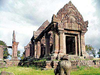
ทางฝ่ายกัมพูชาก็ว่า "สระตาล" ห่างออกมาไกลสองสระที่เป็นที่สรงน้ำของกษัตริย์ขอมข้างหนึ่ง และเป็นที่อาบน้ำชำระร่างกายของพราหมณ์ข้างหนึ่งก่อนขึ้นไปเฝ้าพระอิศวรที่ ปราสาท เป็นส่วนหนึ่งของเทวสถานแห่งนี้
นอกจากนั้น ไกลออกมาถึงสถูปคู่ ซึ่งคงจะหมายถึงประตูทางเข้าพระวิหาร ซึ่งไกลออกมาถึง 2 ก.ม. เป็นเครื่องหมายแสดงขอบเขตของพระวิหาร
รวมทั้งหมดจึงจะเป็นเทวสถานหรือ พระวิหารแห่งพระอิศวรเจ้าที่สมบูรณ์ เหมือนกับอาณาเขตของวัดคงไม่ใช่เฉพาะพระอุโบสถภายในเขตที่ลงลูกนิมิตและ ใบเสมา คงเริ่มจากซุ้มประตูภายในกำแพงทั้งหมด ซึ่งอาจจะมีศาลาราย วิหารคต ศาลา กุฏิพระ ฯลฯ ด้วยประกอบเข้าจึงเป็นวัด หรือ "พุทธสถาน" หรือ "พระวิหาร"
ทางเราก็ตีความว่า คำพิพากษาหมายถึงเฉพาะตัวพระวิหารสิ้นสุดที่บันไดขึ้นวิหารเท่านั้น ดังนั้นพื้นที่รอบพระวิหาร 4.6 ตารางกิโลเมตรจึงยังเป็นของไทย เขมรบอกไม่ใช่ของไทย กัมพูชาไม่เคยรับรู้ ดังนั้นต่างคนต่างอ้างอธิปไตยเหนือพื้นที่ ดังกล่าวจนทางฝ่ายกัมพูชาต้องการขึ้นทะเบียนปราสาทพระวิหารเป็นมรดกโลก ทางยูเนสโกจึงขอให้เขมรเจรจากับไทยว่าจะร่วมกันพัฒนาอย่างไรให้เป็นเทวสถาน ที่สมบูรณ์ เพราะทางขึ้นอยู่ทางฝั่งไทย
หนังสือช่วยจำที่ลงนามโดย รมต. ม.ร.ว.สุขุมพันธุ์ บริพัตร ปี 2543 ก็ถูกต้องแล้ว หนังสือช่วยจำลงนามโดย รมต.นพดล ปัทมะ ที่ทำให้เขมรยอมรับว่าพื้นที่ 4.6 ตร.ก.ม เป็นพื้นที่ทับซ้อนก็ถูกต้อง หนังสือของ รมต. ม.ร.ว.สุขุมพันธุ์เพื่อ ปูทางไปในการปักปันเขตแดน ส่วนของ รมต.นพดล ปัทมะ ก็เพื่อนำไปสู่การขึ้นทะเบียนมรดกโลก และร่วมกันพัฒนาให้เป็นมรดกโลก ทั้ง 2 บันทึกมีประโยชน์กับทั้ง 2 ประเทศและของโลกในแง่สันติภาพและวัฒนธรรมร่วมกัน
ปัญหาที่เกิดขึ้น เกิดขึ้นเพราะนักการเมืองที่ไม่รับผิดชอบใช้ประเด็นความขัดแย้งกับเพื่อน บ้านมาเป็นเครื่องมือทางการเมืองใช้ประหัตประหารกันทางการเมือง โดยอ้างว่าเพื่อประโยชน์ของชาติ แท้จริงแล้วก็เพื่อประโยชน์ของตนเอง เมื่อฝ่ายหนึ่งทำเรื่องให้ง่ายให้เป็นประโยชน์ร่วมกัน อีกฝ่ายต้องการให้เป็นเรื่องยากให้เป็นโทษกับประเทศชาติ อีกฝ่ายหนึ่งก็เป็นนักการเมืองเหมือนกัน มีพรรคฝ่ายค้านเหมือนกัน ก็ใช้กรณีนี้เล่นงานผู้นำของตน เอาอย่างประเทศไทยเรื่องก็เลยทำท่าจะบานปลายไปกันใหญ่
ดีที่ทหารทั้ง 2 ฝ่ายมีความเป็นอารยะพอ ไม่เถื่อนกระโจนไปตามการเมือง ซึ่งต้องชมเชยกองทัพของทั้ง 2 ประเทศ มิฉะนั้นก็ต้องรบกัน พาลูกหลานชาวบ้านไปตายโดยเปล่าประโยชน์
สื่อมวลชนของทั้ง 2 ประเทศก็พลอยไปเล่นการเมืองกับเขาด้วย ไม่ทำหน้าที่อย่างสร้างสรรค์ ไม่เคยศึกษา ไม่อ่านบันทึกของอาจารย์ ดร.บวรศักดิ์ ดร.ชาญวิทย์ คำพิพากษาของศาลโลกก็คงไม่อ่านอยู่แล้ว
ถ้าเรื่องไปถึงคณะมนตรีความมั่นคง คณะมนตรีความมั่นคงไม่มีทางเลือกต้องกลับไปที่ศาลโลกให้ตัดสินให้ชัดเจนว่า พื้นที่ 4.6 ตร.ก.ม.เป็นส่วนหนึ่งของปราสาทหรือไม่ เราก็ไม่มีทางเลือกเพราะได้เคยตกลงให้ศาลโลกพิจารณามาแล้ว
คิดอย่างสามัญสำนึก โอกาสที่เราจะแพ้น่าจะสูงกว่าโอกาสที่จะชนะ ทางที่ดีปล่อยให้คลุมเครือดีกว่าให้ศาลโลกตัดสินอีกครั้ง โดยถือว่าเป็นประโยชน์ร่วมกัน น่าเสียใจที่เราไปเล่นการเมืองกันจนวิถีทางการแก้ปัญหาที่พัฒนามาด้วยดีนั้น กำลังพังทลายลง พอรัฐบาลจะลงก็ต้องหาบันไดลง
แต่ก็มีคนกำลังจะชักบันไดออกไม่ให้ลง
เมื่อปี 2506 พวกเรานิสิตรัฐศาสตร์ วิชาการปกครอง ต้องเรียนวิชากฎหมายแพ่งและพาณิชย์ บรรพ 5 และบรรพ 6 ว่าด้วยครอบครัวและมรดกกับท่านศาสตราจารย์ ม.ร.ว.เสนีย์ ปราโมช ซึ่งท่านเป็นคนไทยคนหนึ่งที่ร่วมอยู่ในคณะทนายของฝ่ายไทย หัวหน้าคณะทนายความของไทยเป็นฝรั่งเข้าใจว่าเป็นอเมริกัน ส่วนหัวหน้าทนายความของฝ่ายกัมพูชาเป็นชาวฝรั่งเศส
พวกเราก็กราบเรียนถามท่านอาจารย์ ม.ร.ว.เสนีย์ ปราโมช ว่า ประเด็นที่ต่อสู้กันนั้นว่าอย่างไร ท่านก็บอกให้พวกเรากลับไปอ่านคำพิพากษาของศาลโลกเสียก่อนแล้วท่านจะอธิบาย ให้ฟัง
เมื่ออ่านจบแล้วเราก็เข้าใจขึ้นเป็นอันมาก เพราะคำพิพากษาเขียนเหตุผลไว้อย่างละเอียด ทั้งคำฟ้องร้องของกัมพูชาและคำแก้คดีของฝ่ายไทย รวมทั้งเอกสารสนธิสัญญาแผนที่แนบท้ายสัญญา ลายพระหัตถ์ของสมเด็จกรมพระยาดำรงราชานุภาพ ที่ทรงมีไปถึงข้าหลวงฝรั่งเศสประจำกัมพูชา เรื่องขออนุญาตเสด็จไปเยี่ยมชมเขาพระวิหาร ภาพถ่ายสมเด็จกับ ม.จ.พูนพิศมัย พระธิดาเสด็จเขาพระวิหาร
ประเด็นที่ต่อสู้กันก็คือ แผนที่แนบท้ายสนธิสัญญาฉบับปี 1904 ที่ให้เอาสันปันน้ำเป็นเขตแดน แต่แผนที่แนบท้ายใช้มาตราส่วน 1 : 200,000 ขีดมาตามสันปันน้ำ แล้วมาวกเอาปราสาทเขาวิหารไปเป็นของกัมพูชา แล้วจึงวกกลับมาบนสันปันน้ำอีกทีหนึ่ง
เรารู้ว่าแผนที่นั้นผิดไม่ตรงกับตัวหนังสือในสนธิสัญญาปักปันเขตแดน ค.ศ. 1904 อีกทั้งไทยไม่เคยยอมรับแผนที่ที่ฝรั่งเศส ทำฝ่ายเดียวแล้วส่งมาให้ไทย ไทยรับรองให้ความเห็นชอบเพราะฝ่ายไทยไม่ได้ส่งตัวแทนไปร่วมคณะปักปันเขตแดน ตามที่ระบุไว้ในสนธิสัญญา
แต่ในที่สุดศาลโลกตัดสินว่าปราสาทพระวิหารเป็นของกัมพูชา เพราะแผนที่ แนบท้าย ค.ศ. 1904 เป็นส่วนหนึ่งของ สนธิสัญญาทั้งในแง่เอกสารและข้อเท็จจริงที่ทางไทยไม่ได้ทักท้วงภายใน 10 ปี อีกทั้งหัวหน้าคณะปักปันเขตแดนของฝ่ายไทยจะเสด็จเยี่ยมปราสาทพระวิหารก็ทรง มีลายพระหัตถ์ขออนุญาตข้าหลวงฝรั่งเศส ข้าหลวงฝรั่งเศสก็ออกมารับเสด็จพร้อมกับชักธงชาติฝรั่งเศสขึ้นสู่ยอดเสา มีการถ่ายรูปร่วมกัน
อาจารย์ ม.ร.ว.เสนีย์ ปราโมช ท่านเล่าให้พวกเราลูกศิษย์ฟังว่า ท่านรู้แต่แรกแล้วว่าเราคงจะแพ้คดี แต่โดยหน้าที่ที่เป็นคนไทยและจรรยาบรรณของทนายความก็ต้องทำหน้าที่ปกป้องผล ประโยชน์ของประเทศชาติอย่างถึงที่สุด
ท่านเล่าว่าทางที่ถูกเราไม่ควรตกลงให้กัมพูชานำคดีขึ้นศาลโลก เพราะคดีที่จะขึ้นสู่ศาลโลกได้ทั้งสองฝ่ายต้องยินยอมให้ศาลโลกพิจารณา
แต่จอมพลสฤษดิ์ท่านต้องการรักษาเกียรติภูมิของชาติว่าเราเป็นชาติอารยะ เป็นสมาชิกที่ดีขององค์การสหประชาชาติ และทนายฝรั่งเชื่อว่าฝ่ายเราจะเป็นฝ่ายชนะ อาจารย์ ม.ร.ว.เสนีย์ท่านเป็นเสียงข้างน้อย เมื่อนายกรัฐมนตรีตัดสินใจแล้วท่านก็ต้องทำหน้าที่อย่างดีที่สุด ในฐานะที่มีอาชีพทนายความและเป็นคนไทย
เมื่อฝ่ายเราแพ้คดีแล้ว ก็แปลว่าเราไม่มีทางเลือกอื่นนอกจากต้องยอมรับว่า แผนที่แนบท้ายสนธิสัญญาเป็นส่วนหนึ่งของสนธิสัญญา มีผลบังคับใช้เหมือนกับกรณีเจดีย์สามองค์ ที่ด่านเจดีย์สามองค์ที่อังกฤษขีดวกเข้ามาทางฝ่ายไทยเป็นปากนกแก้วให้เป็น ของพม่า
ปัญหาก็คือ ความชัดเจนว่าขอบเขตปราสาทพระวิหารนั้นกินขอบเขตพื้นที่ไปถึงไหน เพราะแผนที่ที่ฝรั่งเศสส่งมาให้ไทยเรารับรองหรือทักท้วงนั้นใช้มาตราส่วนย่อ มาก ดูได้ไม่ชัด
คณะรัฐมนตรีในสมัยจอมพลสฤษดิ์จึง ตีความคำพิพากษาว่า ขอบเขตของปราสาทพระวิหาร หรือ "The Temple of Pra Vihar" (สื่อมวลชนไทย สะกดภาษาอังกฤษตามสำเนียงเขมรว่า The Temple of Preach Vihear ซึ่งไม่ควรสะกดอย่างฝรั่ง ควรสะกดตามสำเนียงไทย หรือสำเนียงแขกเจ้าของภาษาสันสกฤตว่า The Temple of Pra Vihar อาจจะเพราะความไม่รู้หรือไม่ก็เพราะเห่อฝรั่ง) มีขอบเขตแค่ไหน
ทางฝ่ายกัมพูชาก็ว่า "สระตาล" ห่างออกมาไกลสองสระที่เป็นที่สรงน้ำของกษัตริย์ขอมข้างหนึ่ง และเป็นที่อาบน้ำชำระร่างกายของพราหมณ์ข้างหนึ่งก่อนขึ้นไปเฝ้าพระอิศวรที่ ปราสาท เป็นส่วนหนึ่งของเทวสถานแห่งนี้
นอกจากนั้น ไกลออกมาถึงสถูปคู่ ซึ่งคงจะหมายถึงประตูทางเข้าพระวิหาร ซึ่งไกลออกมาถึง 2 ก.ม. เป็นเครื่องหมายแสดงขอบเขตของพระวิหาร
รวมทั้งหมดจึงจะเป็นเทวสถานหรือ พระวิหารแห่งพระอิศวรเจ้าที่สมบูรณ์ เหมือนกับอาณาเขตของวัดคงไม่ใช่เฉพาะพระอุโบสถภายในเขตที่ลงลูกนิมิตและ ใบเสมา คงเริ่มจากซุ้มประตูภายในกำแพงทั้งหมด ซึ่งอาจจะมีศาลาราย วิหารคต ศาลา กุฏิพระ ฯลฯ ด้วยประกอบเข้าจึงเป็นวัด หรือ "พุทธสถาน" หรือ "พระวิหาร"
ทางเราก็ตีความว่า คำพิพากษาหมายถึงเฉพาะตัวพระวิหารสิ้นสุดที่บันไดขึ้นวิหารเท่านั้น ดังนั้นพื้นที่รอบพระวิหาร 4.6 ตารางกิโลเมตรจึงยังเป็นของไทย เขมรบอกไม่ใช่ของไทย กัมพูชาไม่เคยรับรู้ ดังนั้นต่างคนต่างอ้างอธิปไตยเหนือพื้นที่ ดังกล่าวจนทางฝ่ายกัมพูชาต้องการขึ้นทะเบียนปราสาทพระวิหารเป็นมรดกโลก ทางยูเนสโกจึงขอให้เขมรเจรจากับไทยว่าจะร่วมกันพัฒนาอย่างไรให้เป็นเทวสถาน ที่สมบูรณ์ เพราะทางขึ้นอยู่ทางฝั่งไทย
หนังสือช่วยจำที่ลงนามโดย รมต. ม.ร.ว.สุขุมพันธุ์ บริพัตร ปี 2543 ก็ถูกต้องแล้ว หนังสือช่วยจำลงนามโดย รมต.นพดล ปัทมะ ที่ทำให้เขมรยอมรับว่าพื้นที่ 4.6 ตร.ก.ม เป็นพื้นที่ทับซ้อนก็ถูกต้อง หนังสือของ รมต. ม.ร.ว.สุขุมพันธุ์เพื่อ ปูทางไปในการปักปันเขตแดน ส่วนของ รมต.นพดล ปัทมะ ก็เพื่อนำไปสู่การขึ้นทะเบียนมรดกโลก และร่วมกันพัฒนาให้เป็นมรดกโลก ทั้ง 2 บันทึกมีประโยชน์กับทั้ง 2 ประเทศและของโลกในแง่สันติภาพและวัฒนธรรมร่วมกัน
ปัญหาที่เกิดขึ้น เกิดขึ้นเพราะนักการเมืองที่ไม่รับผิดชอบใช้ประเด็นความขัดแย้งกับเพื่อน บ้านมาเป็นเครื่องมือทางการเมืองใช้ประหัตประหารกันทางการเมือง โดยอ้างว่าเพื่อประโยชน์ของชาติ แท้จริงแล้วก็เพื่อประโยชน์ของตนเอง เมื่อฝ่ายหนึ่งทำเรื่องให้ง่ายให้เป็นประโยชน์ร่วมกัน อีกฝ่ายต้องการให้เป็นเรื่องยากให้เป็นโทษกับประเทศชาติ อีกฝ่ายหนึ่งก็เป็นนักการเมืองเหมือนกัน มีพรรคฝ่ายค้านเหมือนกัน ก็ใช้กรณีนี้เล่นงานผู้นำของตน เอาอย่างประเทศไทยเรื่องก็เลยทำท่าจะบานปลายไปกันใหญ่
ดีที่ทหารทั้ง 2 ฝ่ายมีความเป็นอารยะพอ ไม่เถื่อนกระโจนไปตามการเมือง ซึ่งต้องชมเชยกองทัพของทั้ง 2 ประเทศ มิฉะนั้นก็ต้องรบกัน พาลูกหลานชาวบ้านไปตายโดยเปล่าประโยชน์
สื่อมวลชนของทั้ง 2 ประเทศก็พลอยไปเล่นการเมืองกับเขาด้วย ไม่ทำหน้าที่อย่างสร้างสรรค์ ไม่เคยศึกษา ไม่อ่านบันทึกของอาจารย์ ดร.บวรศักดิ์ ดร.ชาญวิทย์ คำพิพากษาของศาลโลกก็คงไม่อ่านอยู่แล้ว
ถ้าเรื่องไปถึงคณะมนตรีความมั่นคง คณะมนตรีความมั่นคงไม่มีทางเลือกต้องกลับไปที่ศาลโลกให้ตัดสินให้ชัดเจนว่า พื้นที่ 4.6 ตร.ก.ม.เป็นส่วนหนึ่งของปราสาทหรือไม่ เราก็ไม่มีทางเลือกเพราะได้เคยตกลงให้ศาลโลกพิจารณามาแล้ว
คิดอย่างสามัญสำนึก โอกาสที่เราจะแพ้น่าจะสูงกว่าโอกาสที่จะชนะ ทางที่ดีปล่อยให้คลุมเครือดีกว่าให้ศาลโลกตัดสินอีกครั้ง โดยถือว่าเป็นประโยชน์ร่วมกัน น่าเสียใจที่เราไปเล่นการเมืองกันจนวิถีทางการแก้ปัญหาที่พัฒนามาด้วยดีนั้น กำลังพังทลายลง พอรัฐบาลจะลงก็ต้องหาบันไดลง
แต่ก็มีคนกำลังจะชักบันไดออกไม่ให้ลง
ที่มา: ประชาชาติธุรกิจ ฉบับวันที่ 16-18 สิงหาคม 2553